Liber Floridus

Early 12th century cartography
Almost every history of cartography features maps from the Liber Floridus. The manuscript is exceptionally important in the study of historical maps, containing maps of the mappae mundi type, which had a predominantly moralizing and didactic purpose. Historical cartography studies these maps within their specific historical framework. The mappa mundi is often a cartographical reflection of biblical and factual history. The three most important events in the history of Christianity are nearly always present: the Creation, Christ’s redemption and the Last Judgement. After the Crusades, Jerusalem would be given a prominent place on the map as well.
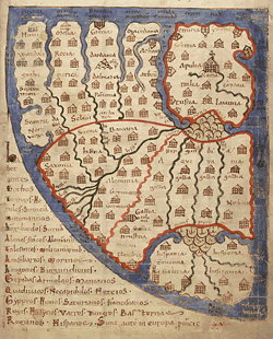
Ghent University Library, Ms. 92, f. 241r: Europe
The best known form of mappae mundi is the Tripartite or T-O-map. This three-part representation of the inhabited world surrounded by an encircling ocean has long been misinterpreted as a representation of a flat earth.
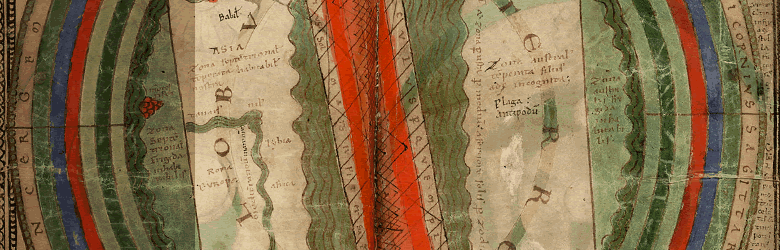
In historical cartography, the Zonal map, like the T-O map, is a category in itself. The Liber Floridus, and its copies, contains the Zonal map inspired by Martianus Capella’s De nuptiis Philologiae et Mercurii (On the Marriage of Philologia and Mercury) (410-439). The ecliptic, the apparent circle that the sun describes against the celestial sphere during its annual orbit, with the twelve signs of the Zodiac, is projected on to the equatorial ocean. The east is placed at the top and the southern hemisphere is covered with text. The coastlines are smoothed out, and the zones that give their name to the map are not explicitly visible. In the ocean surrounding the northern continent there are a large series of islands.
Bibliography:
Brincken, A.-D. Von den, Europa in der Kartographie des Mittelalters, in Archiv für Kulturgeschichte 55 (1973), p. 289-304.
Brincken, A.-D. von den, en A.Zimmerman, Ut describeretur universus orbis. Zur Universalkartographie des Mittelalters, in A.Zimmerman, Miscellanea Mediaevalia 7, Methoden in Wissenschaft und Kunst des Mittelalters, Berlin, 1970, p. 249-278.
Brincken, A.-D.von den, Mappa mundi und chronographia. Studien zur imago mundi des abendländischen Mittelalters, Deutsches Archiv für Erforschung des Mittelalters 24 (1968), p. 118-186.
Harvey, S., Medieval Maps. An Introduction, in J.B. Harley en D.G. Woodward, Cartography in Prehistoric, Ancient, and Medieval Europe and the Mediterranean, Chicago/London, University of Chicago Press, 1987, p. 286-338, esp. 342, 353-354.